Machame Kilimanjaro
Whisky route, steeper and more scenic

Whisky route, steeper and more scenic
Machame Route Kilimanjaro – The Most Scenic Route to Climb Mount Kilimanjaro
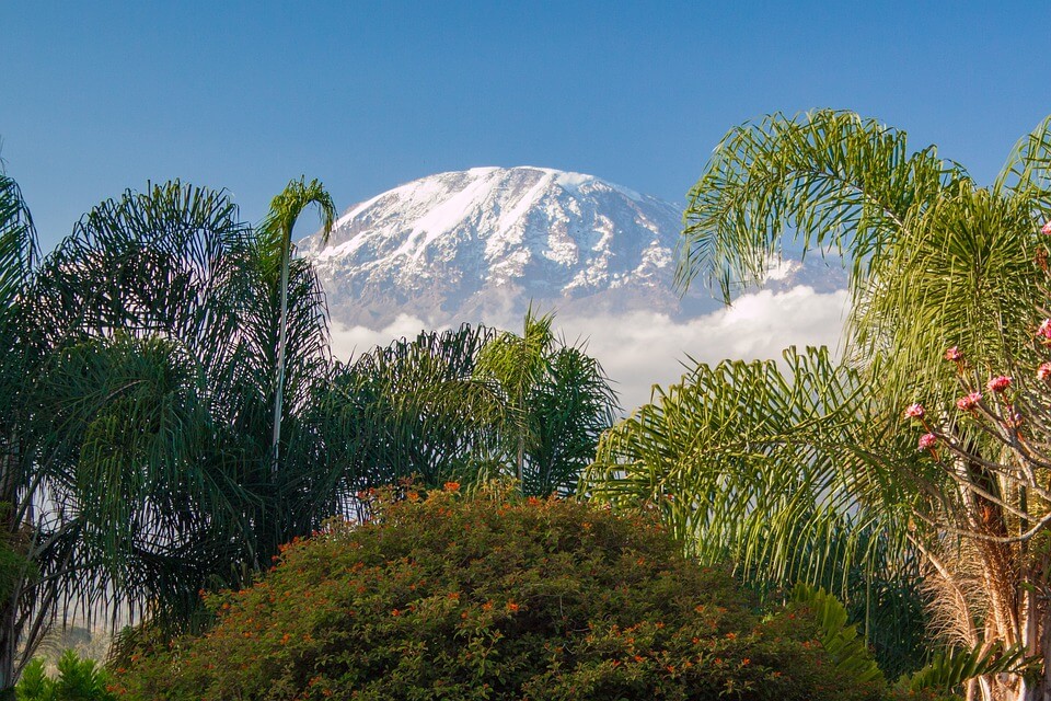
If you’re searching for the most scenic route up Mount Kilimanjaro, the Machame Route is widely considered the best choice. Often called the “Whisky Route,” this classic Kilimanjaro trekking route offers a thrilling and visually stunning adventure, passing through multiple ecological zones and delivering breathtaking views throughout the climb.
The Machame Route Kilimanjaro begins in lush rainforest and ascends through alpine meadows, rocky ridges, and dramatic volcanic deserts, making it one of the most diverse and rewarding ways to climb Mount Kilimanjaro in Tanzania.
Starting at Machame Gate, trekkers hike through moss-covered forests filled with mist-draped trees, vibrant violets, and red-hot poker flowers.
As altitude increases, dense forest gives way to scrubland, dotted with giant lobelias and daisy bushes. By the time you reach Shira Ridge, the landscape transforms into a stark alpine desert, with glaciers stretching toward Lava Tower, the Arrow Glacier, and the Southern Ice Fields.
With its constantly changing scenery, the Machame Route is a dream for photographers and nature lovers, showcasing Kilimanjaro in all its raw beauty.
Why Choose the Machame Route?
* One of the most scenic Kilimanjaro routes
* High summit success rate with proper acclimatization
* Excellent “climb high, sleep low” profile
* Rich variety of landscapes and ecosystems
* Ideal balance of adventure and accessibility
Although the Machame Route is often completed in 6 days, a 7-day Machame Route itinerary is strongly recommended to improve acclimatization and increase summit success.
While it is busier than routes like Lemosho or Shira, the Machame Route offers a perfect balance of beauty, challenge, and safety when climbed at a steady pace.
The trek starts with a short drive from Moshi to Machame Gate. The trail climbs steeply through rainforest toward the Shira Plateau, where it later merges with the Lemosho and Shira routes near Lava Tower. From there, the route crosses dramatic alpine terrain, descends to Barranco Camp, continues through Karanga Valley, and reaches Barafu Camp, the base for the final summit push.
Descent is via Mweka route
Being equatorial, Tanzania has two wet
seasons.
The first is the long rains from March to May, and then a short rainy season in
November. The daytime temperatures tend to range
around 32 to 38 degrees C in the forest, to anything from -2 to 6
degrees at the summit. Nights tend to range from 10 degrees down to well
below freezing. Summit temperatures can drop below -20C.
Distances trekked per day vary,
between 6km’s on day two, to close on 30km’s on the day of your summit,
dependent on which route you take.
The warmest months with the clearest trekking days on Kilimanjaro, are from mid to late December, January, February, September and
October. The rains often come in April and the start of May with the
possibility of some snow. June through to August are superb trekking
months, though evening temperatures tend to be colder. The wettest
months on Kilimanjaro are
November and early December, where snowfalls are likely. Note, that as
this is a mountain it is not impossible to get sporadic snow or rainfall
at odd times throughout the year, although the snow normally only falls
above 4800m.
As part of your Kilimanjaro Park Fee, emergency evacuation services
are included. This means that you will be carried down to the base of
the mountain as quickly as possible, on a mountain stretcher. In many
cases, a foot evacuation is quicker than waiting for insurance cover to
arrange the logistics for a helicopter.
There
are helicopter evacuation points on all of the major routes at specific
locations, namely Horombo, Barranco, Barafu, Kosovo, Stella, Millennium
and Shira. All points are within less than five hours from the crater
by stretcher and SAR emergency medical service can be deployed within 5
minutes from Kilimanjaro or Meru, regardless of the season.
Of course, nothing is free and deployment of this service is
contingent on you already have an insurance covers for evacuations to
6,000 meters above sea level.
So lets start with the worst problem of all; human waste. It
is something we all need to do at some point of the day and there are purpose
built toilets at each camp and at some places along the route. If you are on Marangu
you will find nice flush toilets but for the rest of the mountain they are long
drops. Lower down the mountain in the forest zone and at the first camps, the
toilets smell due to low altitude and warm weather during the day. The effect
of this is that many people elect to go outside the toilet in the surrounding
area, resulting in unwanted piles of human waste and toilet paper littering the
area. The situation at Crater camp at 5700m is even more dire, where they are
no custom toilets meaning that the only places to go are in and around crater
camp itself. Due to the sub zero temperatures, nothing freezes. Between camps,
there are few, if any toilet facilities.
For the reasons mentioned above, regardless of how dire the
conditions are in the toilet we ask that climbers make use of them. They are there for good reason. Take
Vicks and
rub it under your nose if you must. If
not, hire a toilet tent where the waste can be properly disposed of. And if you
really do need to go between camps, find yourself a “loo with a view” a good
20m off the trail and away from any streams, dig and hole and bury your
deposit.
Everything that is carried up the mountain that is not consumed must be brought back down again. At every camp, the gear that the porters carry must be weighed on leaving each camp and again on arriving to the next one. KINAPA enforces strict regulations to keep Kilimanjaro clean. Licenses are easily revoked or heavy fines imposed if it is found that a guide is leaving litter on the mountain. So in theory, all you have to do is give your little paper bag to the kitchen team to be carried off the mountain or better still, leave it in a bag in your duffel and dispose of it when home. Why paper bag? Simple, plastic is a global curse and as of 1 June, Tanzania has banned the use of plastic bags. Anyone arriving into Tanzania will have to “surrender” plastic bags in their possession before entering the country. En route to summit, sucking on glucose sweet helps with thirst and a dry mouth but sadly, most of those sweet wrappers find there way to the scree paths. If you have the energy to dig out a sweet and open it, then you have the energy to put the wrapper back in your pocket. The same applies to hand warmers and dead camera batteries.
The cost of a medical evacuation from the mountain is expensive, which is why adequate travel insurance is required on all climbs booked through us. Adequate, means you must be covered for
1) Trekking or hiking – this may sound strange, but many insurance list that as an exclusion.
2) Altitude up to 6,000 meters. Most travel insurance providers do
not include this under their standard cover and often limit it to 3500m
or less.
3) Sprains strains and physiotherapy – yes, many insurers exclude
this; though ironically, this is what you will most likely need cover
for.
4) Personal accident – this is the horrible part of insurance. Yes,
you need to be covered in the case of death. We are often told by
clients – “if anything happens to me, just leave me there.” It is not
that simple.
 Email now
MACHAME ROUTE ITINERARY
Day 1: Arrival at Kilimanjaro International Airport – Transfer to Hotel
Arrive at Kilimanjaro International Airport (JRO) where our team will meet you and transfer you to your hotel in Moshi, the gateway to Mount Kilimanjaro trekking. Rest and prepare for your Machame Route climb starting the next day.
Day-2: Machame Gate (1830m) - Machame Camp (2835m)
After a short drive from Moshi to Machame Gate, located near Machame village, we complete registration and permit formalities with Kilimanjaro National Park. Your Kilimanjaro hike officially begins as you trek through lush montane rainforest. Expect a damp trail and possible rain in this zone.
Day-3: Machame Camp (2835m) to Shira Camp 2 (3840m)
Elevation: 2835 metres - 3850 metres
Distance: 9km 5 to 6 hours
Environment: Moorland
Leaving forested terrain, you ascend steeply through moorland. After one hour of climbing, the gradient eases as you reach the Shira Plateau, a high-altitude volcanic plateau — a remnant of an ancient caldera. Trek eastward to Shira Camp 2, located beneath Shira Peak, one of Kilimanjaro’s three volcanic cones. Day-4: Shira Camp 2 (3840m) to Lava Tower (4640m) - Barranco Huts (3985m) Elevation: 3840 metres - 3985metres Distance: 12km Trek: 6 to 7 hours Environment: Moorland Today follows the “climb high, sleep low” acclimatization strategy. You hike steadily to Lava Tower (4,640m), a prominent volcanic rock formation. Many trekkers feel the effects of altitude here. After lunch at Lava Tower, descend to Barranco Camp, located at the base of the imposing Barranco Wall.
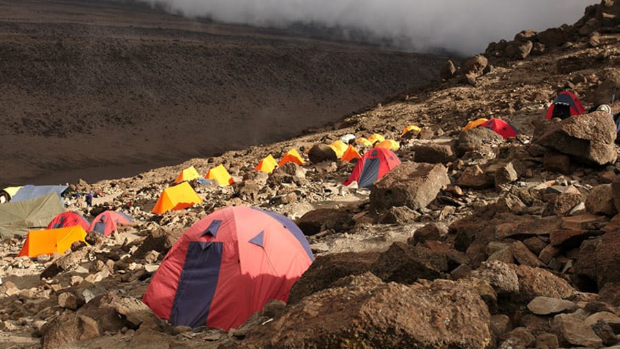
Day-5: Baranco Huts (3985m) to Barafu (4550m)
Elevation: 3985 metres - 4680metres Distance: 13km Trek: 7 to 9 hours Environment: Alpine Desert
Begin with a scramble up the famed BarrancoWall. After admiring views of Heim Glacier, continue across three ridges and valleys to Karanga Valley. After a short break, continue your climb to the high-altitude Barafu Camp, your base for the Kilimanjaro summit attempt. Rest early — tomorrow is summit day.
Day-6: Barafu (4550m)- Uhuru Peak (5895m)-Mweka (3100m)
Elevation: 4600metres to 5895 metres to 3100 metres. Highest: 5895 metres (Summit)
Distance: 30kilometres (7kilometres ascent, 13 kilometres descent)
Trek: 13-16 hours (6 to 8 hours ascent, 7-8 hours descent)
Environment: Stone scree / ice-capped summit
Your Kilimanjaro summit climb begins at midnight. Ascend through volcanic scree toward Stella Point (5,685m) on the Kibo Crater Rim. From there, it’s another 1–2 hours to Uhuru Peak (5,895m) — the highest point in Africa.
After celebrating your summit, descend to Barafu for a short break before continuing down to Mweka Camp. This is the most challenging and rewarding day of your trek.
Day-7: Mweka camp (3100m)- Mweka (1980m)
Elevation: 3100 metres to 1800 metres
Distance: 8 kilometres
Trek time: 3 to 4 hours
Environment: Montane forest
A short descent through the lush forest brings you to Mweka Gate, where your Kilimanjaro trekking adventure ends. Those who reached Stella Point receive a green certificate, and those who summited Uhuru Peak are awarded a gold certificate. Day-8: Depart Transfer to Kilimanjaro International Airport for your return flight. Depart with unforgettable memories of your successful Machame Route climb on Kilimanjaro.
End of services
An accredited Kilimanjaro guide is a mountain guide who is officially authorized and certified to lead climbs on Mount Kilimanjaro.
In plain terms, it means:
✅ They’re licensed by the Tanzanian authorities (through organizations like TANAPA – Tanzania National Parks).
🧭 They’ve completed required training in areas like mountain safety, first aid, rescue procedures, and environmental protection.
🪪 They carry an official guide ID/badge that park rangers can check at entry gates.
🏔️ They’re legally allowed to guide climbers—no accreditation = no guiding on Kili.
Why it matters for you:
Safety: Accredited guides know altitude sickness signs, evacuation routes, and emergency protocols.
Legality: Kilimanjaro cannot be climbed without a registered guide—it’s mandatory.
Ethics: Accredited operators are more likely to follow porter welfare rules and fair labor standards.
Experience: They understand routes, weather patterns, pacing, and acclimatization strategies.
Take a moment to read our blog about the porters on Kilimanjaro
The Machame Route on Mount Kilimanjaro—often called the Whiskey Route—is moderately difficult and known for its steep climbs, high altitude, and excellent acclimatization profile.
The trek starts in lush rainforest, then quickly transitions into moorland and alpine desert, where altitude sickness becomes the main challenge. Key sections like Lava Tower and the Barranco Wall test endurance and confidence, but require no technical climbing skills.
Summit night from Barafu Camp to Uhuru Peak is the hardest part: long, cold, and mentally demanding due to thin air and scree slopes.
Overall, the Machame Route is challenging because of altitude and physical endurance, not technical difficulty, and offers one of the highest success rates on Kilimanjaro thanks to its gradual acclimatization.
The cost of the Machame Trek varies depending on group size, season, inclusions, and domestic flights. On average, trekkers can expect prices $2,545 for a single climber to around $2100 per person for a group of 6-10 people
These fees are mandatory for every climber and are set by TANAPA — you cannot climb Kilimanjaro without them, and your tour operator must pay them before you enter the park.
✔ Conservation fee: $70 per person per day that you spend inside the park.
✔ Camping fee: $50 per person per night on camping routes like Machame.
✔ Rescue fee: $20 per person per climb (one-time charge).
✔ Crew entrance fees (guides/porters/cooks): Tanzanian park charges for support crew are nominal — around 5000 TZS (~$2) per crew member per climb.
✔ VAT (Value Added Tax): 18% VAT is added to most of these park fees.
Park fees alone on a 7-day Machame climb usually total around $900–$1,000+ per person
Guide, Porters & Crew Services
On top of these costs, the following is then added for paying wages and managing staffing:
Note: Prices may vary depending on customisation. Contact us for a detailed quotation based on your preferred travel dates and group size. What we do not do, is charge you for having your own private group. Whether you join a fix departure or choose to trek in private, our costs remain the same.
No. Kilimanjaro is a trekking peak in that you essentially hike or trek to summit. No technical expertise is required, nor use of rope etc. There are sections on the mountain which require a scramble up rocky areas, dependent on which trekking path you follow.
The shortest number of days required to climb to Uhuru Peak is on a 5 day Marangu route, totally 7 by the time you have added on arrival and departure days. However, it is not advisable to do it over 5 as the ascent is very quick and the overall success rate, low. It is better to do the trek over a minimum of 6 or 7 days to increase your chances of success.
There are several streams on the trail and porters will collect water from them. The cook then boils this water for you to fill you water bottles for your days hike. You can also use purifier tablets in stream water or add it to your boiled water however it can also have an effect on the Diamox and make you feel nauseous. The higher you climb the less water there is. On the Machame trail, for example, the last water point is at the Karanga Valley, the lunch-stop before Barafu; on Marangu, it’s just before the Saddle. For this reason it is essential that you carry enough bottles for at least two litres.
Although Kilimanjaro is classified as a ' trek,' it has a very fast altitude gain. Climbing Mount Kilimanjaro requires physical fitness training and stamina and most importantly, mental fitness training. Your legs will get you up the first 4-5 days but for your summit night, mental strength will get you to the top - (assuming of course that you are not affected by altitude, sickness or pure fatigue). A good exercise and training program is essential. The climb should not be undertaken lightly, after all, why spend the money if you are not willing to prepare yourself physically as well
This really depends on the operator you travel through. The parks Kilimanjaro Park authorities do not ask for any medical information on the climbers when permits are purchased. Some operators request the clients complete a medical form, others do not. We require that all of our clients complete a medical form and based on the answers, we may request a letter from your medical practitioner. People suffering with conditions such as severe asthma e.g. should not climb. Regardless, anyone attempting the climb, or any climb for that matter, should ensure that they are medically fit, and convey any medical conditions to the operator they book with.
This is one of the most often asked questions - "how will I cope with the altitude". To be honest, this is an ' unknown' factor as no-one can predict how your body will cope at altitude. People who have been to altitude many times in the past without problems, may on one climb suddenly develop problems. There are many factors that play a role. The only way to help combat this, is to take all of the necessary precautions, and walk slowly, pole pole. Choosing a path like Machame where you get to follow the principle of "climb high, sleep low" is also advisable.
There are certain essentials that are needed for most climbs and Kilimanjaro is no different. The best way to draw up your list is from the base up, i.e. thermal underwear, then hands and feet (gloves, socks etc). Then boots which must be waterproof with good ankle support, trekking pants, trekking tops, short and long sleeve, thermal jacket, outer shell jacket which likewise is windproof and water proof, hat, scarf, beanie, balaclava. Then consider sleeping, i.e. sleeping bag, mat etc. Most companies supply sleeping mats so check before you buy one. Then, the last items to add are personal items like toiletries, camera, medicines, water bottle, backpack, camera etc.
Most companies will supply you with a comprehensive list for your trek, as do we. If you arrive to Kilimanjaro and are missing items, you can normally rent most gear. Do not, however, reply on buying your gear on arrival.
Unfortunately this is something every trekker has to consider. Anything from a stomach bug to altitude sickness can quickly stop a trekker in their tracks. If you are ill and need to turn back or even too tired to continue, a porter will walk off the mountain with you and your gear. If you are too sick to walk, then part of your fee includes evacuation by teams already on the mountain and employed by the Parks authorities.
Yes you do. We (Nomadic Adventures) do not allow anyone to climb with us unless they have adequate travel insurance. Adequate, means you must be covered for
1) trekking or hiking - this may sound strange, but many insurance list that as an exclusion.
2) altitude up to 6,000 meters. Most travel insurance providers do not include this under their standard option and often limit it to 3500m or less.
3) Sprains strains and physiotherapy - yes, many insurers exclude this, though ironically, this is what you will most likely need cover for.
4) personal accident - this is the horrible part of insurance. Yes, you need to be covered in the case of death. We are often told by clients - "if anything happens to me, just leave me there." Bodies need to be brought home or laid to rest overseas, and this can run into thousands of dollars, creating a huge burden on family members.
We will assis t in helping you provide good cover. If you need cover or simply a quote, follow the details herewith. Once you have done your initial quote, you will need to upgrade your cover to include altitudes up to 6000m. Towards the bottom of the page you will see a section called, Options: Upgrade your cover. Click the link called 'View Adventure Sports Benefits'. A blue pop up screen will open. Look for the level of cover required for 'trekking to 6,000 meters' or 'hiking to 6,000 meters'. Depending on your country it is usually a level 1 or 2. Note: we are not insurance experts and it's your responsibility to ensure you have correct and adequate cover. If you live in South Africa, we have other cover options
There are 7 summit routes; namely, Marangu, Rongai, Lemosho, Shira, Umbwe and Machame. Of all, Machame is by far the most scenic albeit steeper path up the mountain. The Rongai is the easiest camping route and the Marangu is also easier but accommodation is in huts. As a result, it tends to be very busy and ascent and descent are the same. Both of the latter have lower prospects to acclimatise by the climb high sleep low principle unless one adds on extra days. The Northern Circuit, approaches Kibo volcano from the west, crossing the caldera of Shira Volcano before turning north to follow the trail through Moir Valley and around the northern side of Kilimanjaro. For a quick overview we have a quick reference panel on the right of the screen. For a detailed look, click onto Kilimanjaro Trekking Routes.
The Kilimanjaro National Park fees are something that nobody can escape and are a large portion of your climb cost.. For a six day/five night camping trek you pay about $800 in fees alone! So on average a climb will cost you between $1450 and $2800 depending on the number of days, number of people and the route that you take. There are some operators who will quote you $1000 for a trek - ask yourself, what are they skimping on and who is going to suffer as a result. You? Your safety? The porters?
There are so many good books written on Kilimanjaro. Some of the ones we suggest are:-
1) Kilimanjaro: The Trekking Guide to Africa' s Highest Mountain by Henry Stedman
2) The Snows of Kilimanjaro by Ernest Hemingway is a short story about a writer who is on safari in Tanzania
3) Kilimanjaro: To the Roof of Africa by Audrey Salkeld.
A link to Mount Kilimanjaro National Park website
Kilimanjaro National Park -UNESCO World Heritage Centre
Acute mountain sickness: MedlinePlus Medical Encyclopedia
Those who have climbed Mount Kilimanjaro know that the porters are the heart and soul of your trek. Without their hard work and strength we would not be able to fully experience the magnificence of Kilimanjaro. A link to the Kilimanjaro Porters Assistance Project
We arrange treks from just 1 person on their own with a guide and porters to large groups. If you climb alone you will still get to meet other people on the mountain if you are sociable.
The Barranco Wall is one of the most famous landmarks on Mount Kilimanjaro, encountered by trekkers on the Machame Route and Lemosho Route. Rising steeply above the Barranco Valley, the wall is known for its dramatic appearance, hands-on scrambling, and unforgettable views. But beyond the climb itself, the Barranco Wall tells a much older geological story.
Mount Kilimanjaro is a stratovolcano, formed through repeated volcanic eruptions over hundreds of thousands of years. The rock that makes up the Barranco Wall originated as lava flows and volcanic deposits, which cooled and hardened as the mountain grew. These layers created the foundation of the wall long before humans ever set foot on the slopes.
As Kilimanjaro’s massive volcanic structure aged, parts of the cone became unstable. Large sections collapsed under their own weight, causing landslides and leaving behind steep,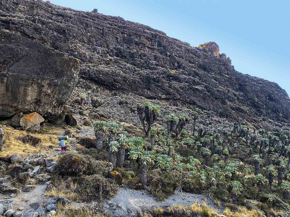 exposed rock faces. The Barranco Wall is the visible edge of one such collapse—essentially a scar left by the mountain’s shifting structure. After the collapse, erosion shaped the Barranco Wall into its present form. Rainfall, gravity, and freeze–thaw cycles gradually removed softer rock while leaving behind stronger volcanic material. Over thousands of years, this process sharpened the wall’s vertical profile and carved the natural ledges used by climbers today.
The wall, often called the Breakfast Wall because it is climbed straight after breakfast, rises approximately 250–300 meters (800–1,000 feet) above the Barranco Valley, creating a striking visual contrast against the surrounding alpine landscape. Deep fractures and vertical lines in the rock add to its dramatic appearance while also providing natural climbing routes. From below, the wall appears intimidating; from above, it reveals sweeping views across Kilimanjaro’s southern slopes.
Is it a “wall” – well no it is not, in the sense that a wall is pretty much vertical which Barranco is not. It consists of a rocky path that zig zags up the rock section of the mountain. Yes it is steep, let us not deny that fact, but do-able? Definitely! While physically demanding, it requires no technical climbing skills and is entirely achievable for most trekkers with a head for heights. It is often considered one of the most enjoyable and memorable sections of a Kilimanjaro trek.
The Kissing Rock is a well-known landmark on Mount Kilimanjaro, located on the Barranco Wall along the Machame and Lemosho routes. It’s a narrow rock passage where climbers must press close to the rock face—often leaning in so clos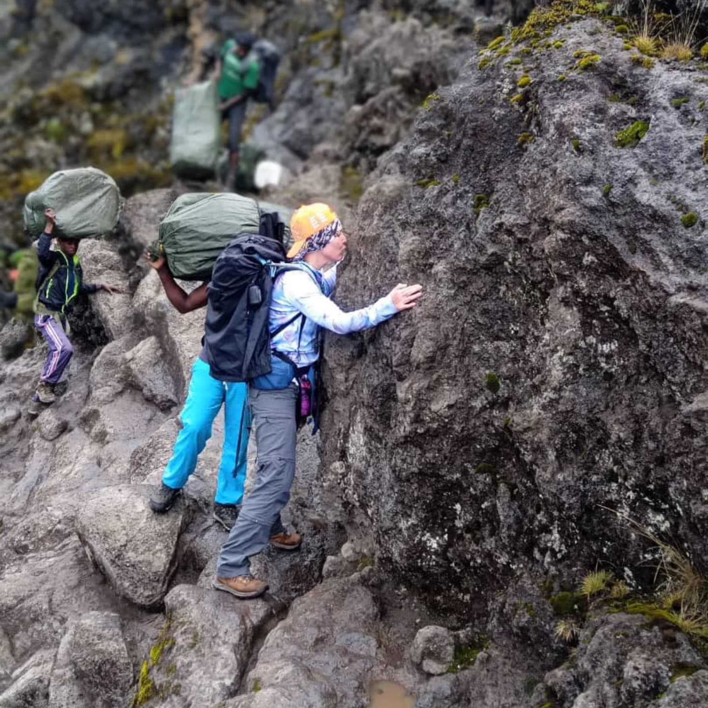 ely that it looks like they are “kissing” the mountain. This is how the feature got its name.
The Kissing Rock is about three-quarters of the way up the Barranco Wall, at an altitude of roughly 4,200 meters (13,800 ft). It marks one of the most memorable moments of the climb, both visually and mentally.
The Barranco Wall is more than just an obstacle on the trail—it is a visible record of Kilimanjaro’s volcanic past, shaped by collapse and erosion over immense time. Each step across its ledges is a walk through the mountain’s geological history, making the climb both physically engaging and deeply connected to the forces that formed Africa’s highest peak.
The Barranco wall is along the Machame Route, Shira Route, Lemosho Route and Umbwe Route.